Guide details
Best time to visit
October to March, when the heat and glare off the sand are bearable
How to get there
Fly or take an overnight train or bus to Rameswaram, then a taxi, auto or local bus for the final 18 to 20 km out to Dhanushkodi
Highlights
Ruined railway station, ruined church, Arichal Munai land\u2019s end, view towards Ram Setu and Sri Lanka, the drive along the sand strip
Good for
history and heritage, photography, a solemn day trip from Rameswaram, road trips, pilgrimage-adjacent sightseeing
Cost
Roughly Rs 1,500 to Rs 4,000 for a full day out from Rameswaram including a taxi or shared jeep; entry to the ruins is free
Dhanushkodi is not a place you visit for a good time. It is a strip of sand at the very end of Tamil Nadu, where a working town once stood and where, in a single night in 1964, it stopped existing. What is left is ruins, wind, an enormous stretch of sea on both sides, and a silence that most visitors say stays with them longer than any temple or beach on this trip.
We would not send you here for a quick thrill. We would send you here because it is honest. It shows what the coast can do, and it ends at one of the most striking points of land in the country, looking out towards Sri Lanka across water that, in myth, Rama’s army once bridged.
Dhanushkodi is usually visited as part of a trip to Rameswaram, the sacred island town just to the north, which our full guide covers in detail.
Where Dhanushkodi is
Dhanushkodi sits at the extreme south eastern tip of Pamban Island, in Ramanathapuram district, roughly 18 to 20 km beyond Rameswaram town, at the literal end of the road. Pamban Island itself is connected to the mainland by the Pamban bridge, and Rameswaram, with its Ramanathaswamy temple, is the last proper town before the island tapers away into sand and sea. From Rameswaram, a single road runs south east across the narrowing strip until it simply stops at Arichal Munai, the tip of India in this direction.
It helps to picture the geography before you go. This is not a headland with cliffs or a harbour. It is a low, flat spit of sand, barely above sea level in places, with the Bay of Bengal on one side and the Gulf of Mannar on the other. That flatness is exactly what made it so vulnerable in 1964, and it is still what makes the place feel exposed today.
The 1964 cyclone and the town that was lost
Before December 1964, Dhanushkodi was a functioning town. It had a railway station connected to the main line, a church, a post office, schools, a customs and port office, and a jetty from which ferries once carried passengers across to Talaimannar in Sri Lanka, then part of the Colombo to India rail and sea link. It was a small but properly built settlement, not a village.
On the night of 22 to 23 December 1964, a severe cyclonic storm, now generally known as the Rameswaram cyclone or the Dhanushkodi cyclone, struck the island with very high winds and a storm surge that swept clean across the low, narrow strip. A passenger train travelling from Pamban to Dhanushkodi was caught in the storm and washed off the tracks with everyone aboard. Across the town and the train, well over a thousand people are believed to have died that night. It remains one of the worst cyclone disasters on this coast.
In the aftermath, the government of the day declared Dhanushkodi unfit for human habitation. The railway line was never rebuilt this far, the town was never reconstructed, and what had been a functioning settlement was simply abandoned to the sea and the sand. We think it is worth knowing this properly before you go, because the ruins make far more sense, and deserve far more respect, once you know what actually happened here.
The ruins today
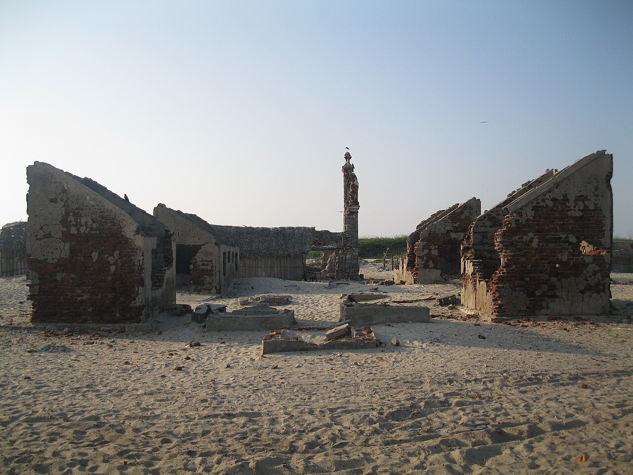
What survives is skeletal. Walls without roofs, doorways that open onto sand, the shell of the old railway station and the outline of platforms that no train has used in six decades. None of it has been restored or rebuilt as a monument. It has simply been left as the sea and the wind have shaped it, which is a large part of why it affects people the way it does.
A small community of fishing families still lives in and around the area, in simple huts, rebuilding a working life on a coast that took almost everything from the town before them. Seeing their boats and nets alongside the ruins is a reminder that this is not purely a historical site. People still make a living here.
Among what you can see:
- The ruined Dhanushkodi railway station, with sections of platform and old structure still standing
- The remains of a church, roofless and open to the sky
- The old water tank and traces of the former post office
- Scattered walls and foundations from what were once homes and shops
- The fishing hamlet, with boats drawn up on the sand and nets drying nearby
Treat it as you would any site connected to a disaster and significant loss of life. It is worth photographing, but worth walking through slowly and quietly too.
Arichal Munai: the end of the road
Beyond the ruins, the road finally runs out at Arichal Munai, the actual land’s end of this part of India. This is where the Bay of Bengal and the Gulf of Mannar visibly meet, with currents and colours that noticeably differ on either side. Standing here, you are looking directly out towards Sri Lanka, whose coast at Talaimannar lies roughly 30 km away across open water, near enough to feel close, far enough that you obviously cannot see land on a normal day.
It is a striking spot simply for what it is, a narrow point of sand with sea on three sides and nothing beyond it but water and horizon. Give yourself real time here rather than a quick photo stop. Most people find it is the part of the trip they remember best.
Ram Setu and the Ramayana
From Arichal Munai, on a clear day, you can make out a faint chain of shoals and sandbanks running out towards Sri Lanka. This is Ram Setu, also known as Adam’s Bridge, a natural formation of shallow limestone shoals stretching across the Palk Strait towards Talaimannar.
In the Ramayana, this stretch is traditionally identified as the causeway built by Rama’s army, with the help of Nala and an army of vanaras, to cross from the Indian mainland to Lanka in order to rescue Sita. For pilgrims and many visitors, this tradition is a significant part of why Dhanushkodi and Rameswaram matter as a destination, alongside the Ramanathaswamy temple back in town. It is worth being clear, though, that Ram Setu is not something you can walk or wade out onto. It is visible only from a distance, largely submerged, and there is no approved crossing.
The drive out along the sand strip
For decades, the only way to reach Arichal Munai was by specially adapted jeeps that drove directly across the loose sand flats, a slow and fairly rough journey that put many casual visitors off. That has changed. A proper metalled road now runs the full distance from Rameswaram out to the tip, which means ordinary taxis, cars and buses can now make the trip without difficulty.
What has not changed is the drive itself. The road runs along an extremely narrow strip with the sea visible on both sides for long stretches, at times barely a stone’s throw away on either hand. It is, in our view, one of the most memorable roads in India, and for a great many visitors the drive out and back is as much a part of the experience as the ruins themselves.
Getting there from Chennai
Dhanushkodi has no separate road, rail or air connection of its own. Every route in runs through Rameswaram, so the honest way to plan this is as an extension of a Chennai to Rameswaram trip rather than a destination in its own right.
Chennai to Rameswaram is roughly 560 to 600 km, which works out to about 11 to 13 hours by road, or an overnight train of roughly 12 to 14 hours that crosses the Pamban bridge on its final approach. From Rameswaram town, it is then a further 18 to 20 km by taxi, auto or local bus out to Dhanushkodi.
Given the distances involved, this is not a day trip from Chennai. Plan on reaching Rameswaram first, staying at least one night, and giving Dhanushkodi a proper half day to a full day of its own once you are there.
Rules, safety and what to bring
Dhanushkodi is remote and genuinely lightly developed, and it is worth going in with the right expectations. There are very few proper shops, little reliable shade, and no facilities to speak of once you are past the last stalls near the ruins.
For safety, vehicles are generally not allowed to stay out at Arichal Munai after sunset, and the road out to the tip is closed in the evening. This means Dhanushkodi is a daytime visit only, and overnight stays are not permitted. Plan your visit so you are back on the road well before dusk.
The waters where the two seas meet have strong and unpredictable currents, and swimming here is not safe. Admire the view from the shore rather than going into the water. Carry your own drinking water, wear a hat and sunscreen, and expect very little shelter from the sun for most of the visit.
Best time to visit and tips
The best months are roughly October to March, when temperatures are more manageable and the glare off the sand and water is easier to deal with. Outside this window, particularly from April to June, the heat and exposure on this open strip can be punishing.
A few practical points worth keeping in mind:
- Start early from Rameswaram so you have the coolest part of the day at Dhanushkodi
- Carry more water than you think you will need, there is little to buy along the way
- Wear closed shoes or sandals that can handle sand and broken ground around the ruins
- Combine the visit with the Ramanathaswamy temple and the Pamban bridge viewpoint in Rameswaram
- If far south land’s ends interest you, the same instinct that brings you here often leads people on to a Chennai to Kanyakumari trip, India’s other great meeting point of seas
Dhanushkodi will not give you the postcard version of a beach holiday, and it should not. It gives you ruins that remember a real storm and real lives, a fishing community that has quietly carried on, and a final stretch of Indian coastline pointing out towards Sri Lanka across water that has carried both tragedy and legend. That combination, sobering and beautiful at once, is exactly why so many people make the journey out to the edge.